Partner Feeds
May 22 - Crews continue with prescribed ignitions in the Starr Project Area (2018 Malheur NF Prescribed Fire Prescribed Fire)
FINAL Incident Update 5-21-18 (Okanogan Flooding 2018 Flood)
May 21, 2018 Prescribed Fire Activity Update (2018 Malheur NF Prescribed Fire Prescribed Fire)
Care for the Land, Care for the People
Harvest this much. Save this type of habitat. Achieve these markers of biodiversity. Traditional approaches to forest management tend to focus on specific ecological and revenue objectives, how much land to dedicate to these objectives, and how to achieve them.
But there is something largely missing from these approaches. Us. Humans. Under traditional approaches, humans exist somewhat outside of the forested ecosystems we are managing, even as we look to the forest to meet our needs.
Yet there is a growing recognition that humans are an integral part of these systems. Consider the interactions and interdependencies of a community and the forest and streams that surround it (Figure 1). The forest needs human intervention to stay safe and healthy due to past timber harvest, fire suppression, and major environmental shifts such as climate change. And communities need the forest’s ecosystem services, which can range from timber for harvest to carbon storage, filtered water, and streams with healthy fish populations for food and recreation. Such services keep communities healthy and more likely and able to care for the forest.
Figure 1. Holistic View of SustainabilityThis recognition is the basis for a sustainable forest management concept that the ONRC and its partners refer to as “rural ecosystem sustainability.” Under this concept, the forest and its communities are defined as a “rural ecosystem” and managed with strategies that benefit both. “To care for the place, you have to care for the people. And to care for the people, you have to care for the place,” says Hilary Franz, the Commissioner of Public Lands and leader of DNR, steward of over two million forested acres that touch the lives of communities across the state.
Although this concept has been documented in recent scientific literature—for example, the 2017 Island Press book People, Forests, and Change: Lessons from the Pacific Northwest described a “human-forest ecosystem”—it has not been tested at a landscape scale. That is about to change. An ambitious new study called the “Large-Scale Integrated Management Experiment” or T3 Experiment for short is being developed to test this holistic sustainability concept across thousands of acres of forest on the western Olympic Peninsula.
A Unique StudyA basic requirement for studying rural ecosystem sustainability is to define an ecosystem that contains people in the context of the surrounding land. The OESF on the western Olympic Peninsula fits this description. Defined largely along watershed lines, the OESF’s boundaries encompass over a million acres of both forestland and communities. Communities include small towns like Forks and four Native American reservations, plus farms and other businesses. Forests are managed for a range of objectives by DNR, tribes, private landowners, conservation organizations, the US Forest Service, and the National Park Service. DNR manages over 270,000 acres in the OESF on behalf of public trust beneficiaries such as counties and schools.
The T3 Experiment’s central purpose is to find a management strategy that lifts the wellbeing of the OESF’s communities and forests above what is being experienced right now. In this study, which is co-led by the University of Washington’s ONRC and DNR, researchers will apply three management strategies and a no-action control on DNR-managed lands in 16 Type 3 watersheds in the OESF (Figure 2). DNR will define ecological and community wellbeing indicators through a collaborative process, quantify how well each strategy meets these indicators over time, and then conduct a comparative analysis to draw conclusions on which strategy improves ecological and community wellbeing the most. (Type 3 watersheds are catchments of the smallest fish-bearing streams.)
Figure 2. One of the 16 Type 3 watersheds in this study Figure 3. Timber Museum in Forks, WA. Timber harvest and management has been part of the city’s history for decades.This is not your typical forestry study.
Forestry studies seldom include something so nebulous….subjective….and difficult to measure as community wellbeing. Elements of environment wellbeing have been studied for decades, and scientific literature abounds for how to do so. For example, many studies have measured biodiversity, productivity, regeneration capacity, and other characteristics.
But community wellbeing can be many things to many people. Jobs. Knowing one’s neighbors. Road access into the forest for recreation. Gathering places like libraries. High school seniors who stay after graduation instead of lighting out at the first opportunity.
So how do you define it?
By asking stakeholders, especially those who live in these communities. Members of the community, local tribes, environmental groups, timber company representatives, and other stakeholders will be invited to define what wellbeing means to them. They may have other opportunities to participate as well, such as workshops. Collaboration with stakeholders is an important feature of this study because there is no way to succeed without involving them, particularly members of the very communities the study is intended to benefit (Figure 3).
Another unique aspect of this study is that each strategy will be implemented through DNR’s Olympic Region timber sale program, not as separate research experiments. This is nothing but practical. “It can be difficult to translate the results of a small research study to normal timber operations,” explains Bill Wells, Coast District Manager with Olympic Region. “We have to be able to incorporate what we learn from this experiment at an operational scale.” So why not start at that scale to begin with? Study units have been sized accordingly.
In other words, researchers are not pursuing knowledge for the sake of knowledge. They want defensible results that can be used to make informed management choices. Through an adaptive management process, results may be used to improve the management of the OESF and possibly other areas DNR manages.
Ideally, results also will benefit forests and communities far beyond the boundaries of the OESF. ONRC and DNR are inviting participation in this study from other land management, academic, and scientific organizations with a major goal of collaborative learning and sharing of knowledge.
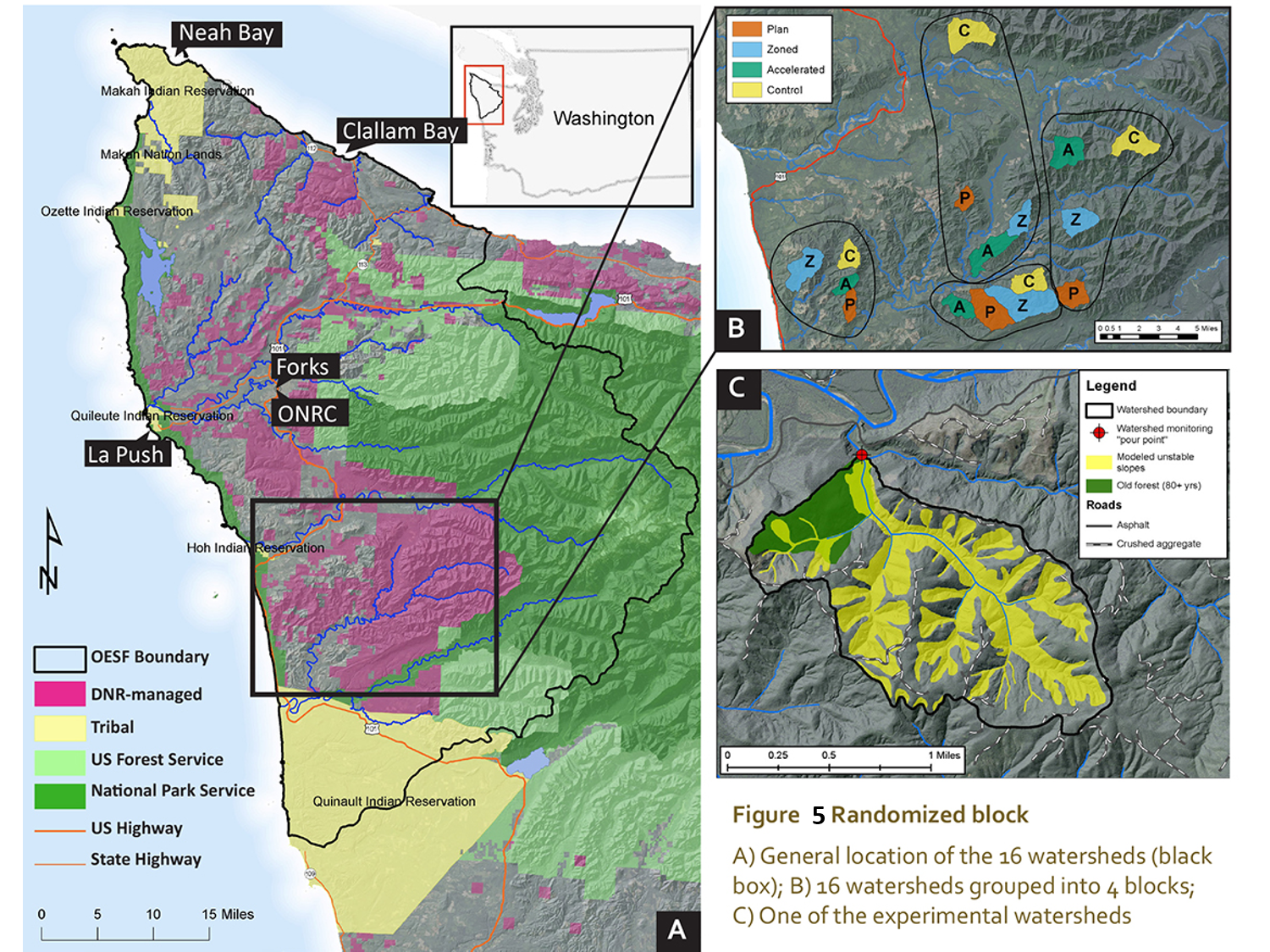
16 Watersheds, 4 Blocks, 4 StrategiesOne of the first steps in this study was to select the 16 Type 3 watersheds in which the strategies would be tested. To yield meaningful results, each watershed had to be at least 500 acres, be managed mostly by DNR, include at least some older or old-growth forest, include the steep slopes that are so common across the OESF, and contain timber that was ready to harvest. Researchers and DNR managers chose watersheds within the basins of the Hoh, Clearwater, and Queets rivers.
Figure 4. DNR Olympic Region manager Mona Griswold rolls dice to randomly assign strategies to watersheds in each block.Researchers grouped watersheds into blocks of four based on how similar the watersheds were to each other. For example, they grouped watersheds that were at a similar elevation, were roughly the same size, and had trees of roughly the same age. Grouping watersheds this way helps to screen out nuisance factors, which are traits like elevation that can skew results and make it difficult to compare results from different watersheds.
Within each block, each watershed was assigned one of the four strategies in a way that was completely random – in this case, by rolling the dice (Figure 4). This spatial design is called a “randomized block” (Figure 5).
Within each block, each watershed will be managed under its respective strategy. Where the harvest will be and what harvest technique will be used will depend on the strategy.
Under the “plan” strategy, the watershed will be managed per the integrated management concept and harvest techniques described in the 2016 OESF Forest Land Plan. Under integrated management, most sensitive areas are managed for ecological values but are not part of fixed, permanent ecological reserves. In areas managed for revenue, DNR uses harvest techniques designed to create and maintain a structurally varied forest that can provide additional support for ecological values as well as revenue.
Integrated management is a marked contrast to the “zoned” strategy, which is widely used by the US Forest Service as well as DNR in other areas it manages. Under the zoned strategy, the watershed is divided into permanent areas or “zones” for either ecological values or timber harvest. Harvests will be located in the latter; the former will be left unmanaged. Techniques likely will be similar to the plan strategy.
The “no-action control” is not a viable management strategy for DNR under state law. However, these watersheds will provide a contrast to active management and enable researchers to understand how the forest interacts with natural disturbance in absence of management. The control strategy also reflects stakeholder interest in managing some areas as carbon sinks and using carbon payments in lieu of harvest to generate revenue. DNR is committed to leaving these four watersheds unmanaged for 10 years.
The “accelerated” strategy is similar to the plan but with one key difference: management will explore techniques and areas that are more innovative or uncertain but may offer greater benefits to both community and environment. For example, DNR may thin riparian areas to a wider spacing than is currently allowed under the plan in the hope of producing larger trees that contribute higher-quality down wood to streams. DNR also may experiment with “tethered logging,” in which logging equipment is tethered to the slope with cables. Tethered logging is more cost effective than cable logging and safer for forest workers, and may enable DNR to operate on steeper slopes than is currently feasible with ground-based equipment.
There is a general perception that the accelerated strategy may spur the most creative answers to how to boost community and environmental wellbeing (Figure 6). But will it? Time will tell.
Next StepsThe T3 Experiment is in its infancy. After discussing the study proposal with stakeholders and managers in 2016, in 2017 DNR and ONRC began collaborating with scientists from the US Forest Service Pacific Northwest Research Station, Oregon State University, NOAA, and other organizations to develop a draft study plan. The full study plan is being developed and will be submitted for peer review later this year. The watersheds have been selected as described earlier. Next steps include specifying experimental treatments, identifying wellbeing indicators for monitoring, and exploring funding options.
Another step is determining how to quantify community wellbeing indicators for each strategy, and how to tease out the differences between the strategies and how well they support the community. That will take creative problem solving.
However challenging and complex, this study is necessary. Rural communities in Washington and elsewhere are struggling as our demands from the forest become more complex, more numerous, and potentially more conflicting. At the same time, the forest is experiencing environmental changes such as rising temperatures and more extreme weather. We need creative, sustainable, and balanced solutions, and we need them now. This study will not only help find those solutions, but provide a model for working collaboratively to achieve a higher level of wellbeing for forest and community alike.
Figure 6. Examples of wellbeing indicators and how they might perform over a decade or longer C is the no-action control strategy, Z is zoned, P is plan, and A is accelerated. C > Z = P = A means that for CO2 sequestration, researchers think the control strategy will outperform the other three strategies, which will perform roughly the same for this indicator.The Learning Forest is an electronic newsletter published jointly by the Washington State Department of Natural Resources and the University of Washington’s Olympic Natural Resources Center. All newsletter issues are available online. To receive this publication or to be added to the distribution list, go to our sign-up page or contact the editor at cathy.chauvin@dnr.wa.gov.
About the Authors
Bernard Bormann, Ph.D, is a professor at the School of Environmental and Forest Sciences College of Environment, University of Washington and Director of the ONRC. His research includes forest ecology, the role of soils in long-term productivity, and adaptive management.
Marc L. Miller, Ph.D, is a professor of Marine and Environmental Affairs and adjunct professor of Environmental and Forest Sciences at the University of Washington. His domestic and international research has concerned social and cultural change, globalization, sustainable livelihoods, natural resource and protected area governance, and outdoor recreation and tourism.
Teodora Minkova, Ph.D, is a natural resource scientist in DNR’s Forest Resources Division and an affiliate assistant professor at the University of Washington’s School of Environmental and Forest Sciences. She manages the research and monitoring program for the OESF and is one of principal investigators on the T3 Experiment.
Cathy Chauvin is a writer, editor, planner, and graphic designer for DNR. She was part of the team completing the forest land plan and related environmental documents for the OESF.
Incident Update 5-18-18 (Okanogan Flooding 2018 Flood)
Incident Update 5-17-18 (Okanogan Flooding 2018 Flood)
Road Closure Information (Okanogan Flooding 2018 Flood)
Incident Update 5-16-18 (Okanogan Flooding 2018 Flood)
Willow Springs Fire Contained (Willow Springs Fire Wildfire)
Prescribed fire ignitions complete for this week (2018 Malheur NF Prescribed Fire Prescribed Fire)
May 15, 2018 Prescribed Fire Activity Update (2018 Malheur NF Prescribed Fire Prescribed Fire)
May 14, 2018 Conditions in line for further prescribed fire ignitions (2018 Malheur NF Prescribed Fire Prescribed Fire)
May 11, 2018 Prescribed Fire Activity Update (2018 Malheur NF Prescribed Fire Prescribed Fire)
May 10, 2018 Prescribed Fire Activity Update (2018 Malheur NF Prescribed Fire Prescribed Fire)
May 8, 2018 Update (2018 Malheur NF Prescribed Fire Prescribed Fire)
Active Prescribed Fire operations planned to start Friday, May 4 (2018 Malheur NF Prescribed Fire Prescribed Fire)
April 25-Prairie City Ranger District initiates Prescribed Fire operations (2018 Malheur NF Prescribed Fire Prescribed Fire)
Combining mountains and music: Performance duo take their passion to DNR’s Manastash Ridge
Two musicians based in the greater Seattle area are celebrating their love of the outdoors in a rather surprising way – by playing their instruments in the mountains.
As one of the state’s largest public land stewards, we’ve heard of visitors connecting with our state’s working forests and conservation areas in a lot of ways. With over 1,200 miles of trail and 70 campgrounds statewide, it’s no surprise that DNR-managed lands offer some of the most diverse ways to experience the outdoors. You can cross-country ski in the shadow of Mount Rainier, enjoy one of over 25 beachfront campsites in the San Juan Islands, test out your skills on one of our expert-only downhill-only mountain bike trails or rock climb at some of the state’s most brag-worthy destinations.
While some take a trail map or summit snack with them into the outdoors, Anastasia Allison and Rose Freeman, of the Musical Mountaineers, carry a violin and a carefully packed keyboard along with them for sunrise performances in the outdoors, intended to celebrate both their love of music and their love of the outdoors. The early morning performances are aimed at respecting leave no trace principles and finding time so their enjoyment of the outdoors doesn’t impact other visitors.
“Our intent is to share this beautiful combination of music and the wilderness with the world, but we would never do that at the expense of somebody who didn’t want to hear our music live,” Anastasia said.
The duo has performed in the North Cascades National Park, Mount Rainier National Park and this spring stopped by our Manastash Ridge near Ellensburg, which overlooks Kittitas Valley and provides a breathtaking view of the Stuart Mountain Range.
DNR manages Manastash Ridge in partnership with the Washington Department of Fish and Wildlife, which is coordinating a trails planning process to guide recreation development and management for the system for the next 10 to 15 years.
Anastasia and Rose realized early on the impact their music was having – people from all over the world were deeply touched by the combination of music in the mountains.
“[The Manastash performance] meant a lot to the communities that saw those videos online,” Anastasia said.
As you’re out visiting one of DNR’s 160+ recreation sites this summer, you may find Anastasia and Rose celebrating one of your favorite trails. The Musical Mountaineers aren’t super easy to find though – they keep their performances brief, at sunrise and don’t promote them broadly so they don’t draw too much of a crowd.
To watch all of their wilderness concerts, you can visit their YouTube channel: www.youtube.com/themusicalmountaineers
For more information about getting outdoors in DNR working forestland and conservation areas statewide, visit dnr.wa.gov/go.


